The Welney Website
Suspension Bridge, Welney
page created Dec 2005, amended/updated Wednesday, 14 November 2012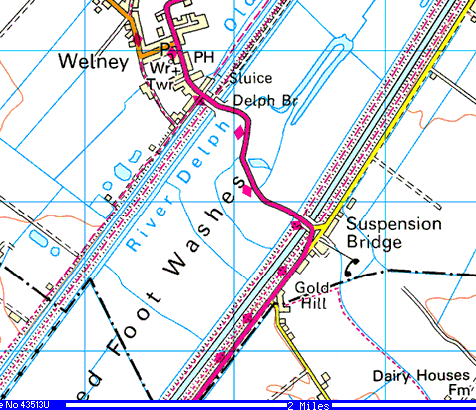
| main website pages |
| Home page & introduction |
| contents & news headlines |
| news & views reports & comment |
| sports and social |
| information centre |
| local government |
| links to local websites & media |
| commerce |
| about this site small print & more |
Click the map top right for a larger image or see the map of 1889 (opens in a new window or tab).
The river here is tidal, and man-made. It was cut in the 1650s as part of Vermuyden's grand plan to drain the land (see link at bottom of page) and some references say a wooden bridge was errected at that time. The river and adjacent land was owned by the Bedford Level Corporation (the successors to the original "Company of Adventurers" who employed Vermuyden) and was probably responsible for maintaining that bridge. However, the Corporation was always short of cash and it is likely that the bridge crumbled away due to neglect. We may never know the true details as many of the Corporation's early records were destroyed in a fire.
No bridge is marked on the OS 1" map of 1824 (which shows the area as 'Washington') and a ferry service had been in use here for many years before that. Then in September 1825 the Revd. William Gale Townley, the rector of the parish of Upwell (of which Welney was then a part) leased a strip of land from the Corporation for 99 years in order to build a bridge. The Rev. Townley financed the cost, around £3,000, but was allowed to charge tolls at rates set out in the lease. The bridge was designed by Captain Sir Samuel Brown, RN, a naval officer and engineer, and was of a relatively new style, a chain suspension bridge, completed in 1826. The area has been known as 'Suspension Bridge' ever since.
More, much more, about the bridge and it's replacements a little further down this page.
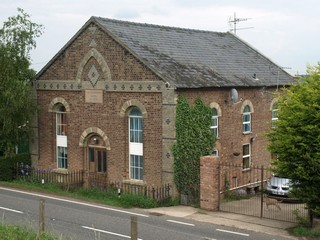
There was also a Primitive Methodist Chapel (now The Old Chapel, right) built in 1872 and a Church of England free school known as the "Mission School" (now Tall Pines) built in 1874 by Marshall's Charity for 80 pupils. It was also licenced for "divine service", held on Sundays. It closed in 1927. The building was badly damaged by fire in April 2006.
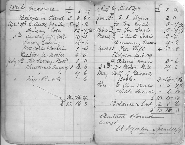 Sunday School accounts, 1896
The book also shows that the children had a day trip to Hunstanton in July 1922. Seaside trips then became an almost annual event, with further trips to Hunstanton in 1924, 1933, 1936 & 1939. However, Yarmouth seemed more popular with trips in 1928-1931, 1934-35 and 1937-38). Most of those events seem to be excursions by rail, but in 1939 it was by Towlers Buses at a cost of £9. The 1930 page shows the cost in detail, and tells us how many were in the party: rail fares, 11 @ 4s 6d and 39 at (half-fare) of 2s 3d, a total of £7 17s 3d for the 50 passengers; bus to the station £1 1s.
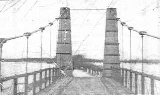
Now back to the suspension bridge. It was of wrought iron with a timber deck. It was 191 feet (58.5 metres) long; the carriageway was 7ft 6ins wide, with a 3ft 4 ins footpath each side. It was opened to the public on 16th August 1826 and was described as a "handsome" bridge.
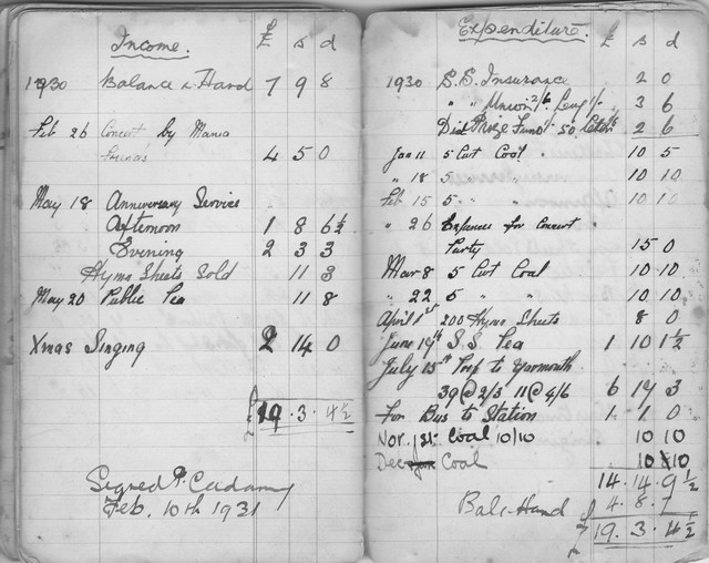 Sunday School accounts, 1930
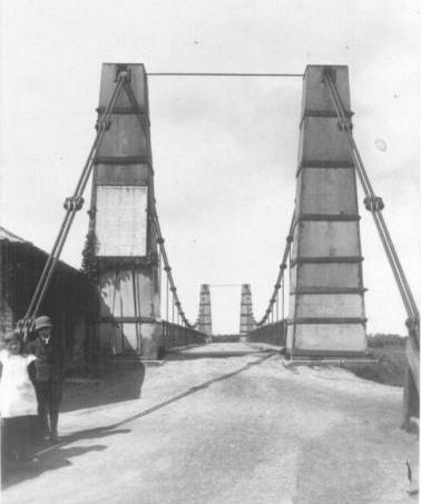
Looking north-west
from the Hundred Foot Bank
The Washes are beyond the far towers.
Toll charges board on left tower.
Behind the children is the toll-house.
|
In 1820, six years before coming to Welney, Capt Brown built the famous "Union" suspension bridge at Berwick-upon-Tweed and in 1823 he designed the world's first seaside pleasure pier,
the Chain Pier at Brighton. Rev'd Townley must have been lucky to have secured his services in 1826. |

Above, looking north. The toll house was on the east bank (the building with tall chimney). Just across the road was the Crown Inn (the white building) and there are tales of the toll collectors spending much of their time in the pub, having paid a young boy to keep watch outside. The photo on the left shows a charges board on the left tower, and the toll house to the left of it. The last toll keepers are said to have been Roger Lavender and Larry Scott.
The bridge was designed when horse drawn waggons were the heaviest traffic. Steam traction engines introduced towards the end of the Victorian era and later steam and petrol lorries damaged the bridge and by the 1920's a three-ton weight limit had been imposed. Barber's Almanack records that Littleport Parish Council in May 1925 discussed its "dangerous state".
So, in 1926, it was replaced by a three-span bridge of reinforced concrete with a central bowstring arch and two short approach spans. The new bridge was erected south of the original bridge as shown below. Note the toll house is still there. It may have been co-incidence that the new bridge was built so soon after the expiry of the Rev. Townley's lease, but I suspect not. The Bedford Level Corporation ceased to exist in 1920, which may also have been a contributory factor. I also assume the new bridge was financed by the County Council.
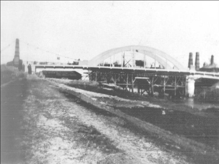
Looking north-west
from the middle of the bridge
onto a familiar scene, then as now,
flooded washes and road.
 Later a more detailed investigation was undertaken by the chartered engineers, Maunsell &
Partners who concluded that it could not be strengthened sufficiently to meet the required
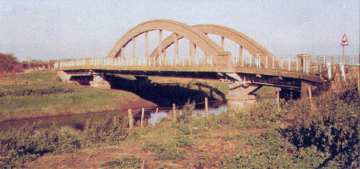
EU standard. The County Council therefore sought
Government funding for a new bridge and in 1992 commissioned Maunsell to carry out feasibility studies. Various designs and alignments were considered.
Later a more detailed investigation was undertaken by the chartered engineers, Maunsell &
Partners who concluded that it could not be strengthened sufficiently to meet the required
EU standard. The County Council therefore sought
Government funding for a new bridge and in 1992 commissioned Maunsell to carry out feasibility studies. Various designs and alignments were considered.
| Further details of the design and construction of the 1996 bridge are on
the Norfolk County Council leaflet.
|


|
Something you would not have guessed about the designer of the original Welney Suspension Bridge,
Captain Sir Samuel Brown, RN. |
|
Acknowledgments. Aerial photos of 1996 bridge courtesy Dick Fiske © 2005. Other photos from the Welney Website archive. Some details of the Suspension Bridge courtesy of David Denenberg in USA. Text by Peter Cox © 2005-2011 |
The current bridge is at a slight angle across the river to lessen the bend on the east bank, but many parishioners commented during the planning stages that the designed re-alignment was insufficient and that the opportunity should be taken to eliminate as much of the bend on the main road as possible. The planners said they were unable to do that, and accidents have occured here regularly ever since.
| Related pages on this website |
| Drainage of the fens |
| Mission School |
| Methodist Chapel |
| Crown Inn |
| Carpenters Arms |
| (all above available late 2010) |
| Overturned lorry October 2010 |
| Tall Pines fire April 2006 |
| Related pages on other websites |
| David Denenberg's bridge website |